 TemperateReefBase Geonetwork Catalogue
Community Ecology
Type of resources
Topics
Keywords
Contact for the resource
Provided by
Years
-

[This data has been superseded by a synthesised global dataset which includes additional ecological data contributed by non-RLS entities (National Reef Monitoring Network). Please visit the corresponding NRMN Collection (IMOS - National Reef Monitoring Network Sub-Facility - Survey metadata) for the most current version of this data. See "Downloads and Links" section below.] This dataset shows the location of Reef Life Survey (RLS) sites surveyed by divers along 50m transects on shallow rocky and coral reefs, worldwide. Although surveys are undertaken as part of monitoring programs at particular locations (mostly in Australia), this dataset contains only spatial information, with repeat surveys of sites not included. Biological data (abundance of invertebrates and fish, habitat quadrats) collected from these surveys is available as separate datasets through the AODN Data Portal (https://portal.aodn.org.au/ - search for 'NRMN')
-

Reef Life Survey is a program that trains and assists a network of skilled and committed recreational divers to cost-effectively assess the state of the inshore marine environment at the continental scale. The program uses standardised underwater visual census methods employed by SCUBA divers to survey fish and invertebrate species and to record macroalgal and coral cover using photo quadrats - this record refers to the website for this program. By standardising techniques and establishing a monitoring system on a nation-wide scale, the program addresses many of the current problems associated with managing the marine environment, including the paucity, patchiness and variable quality of data on the distribution of and trends to marine biodiversity. A central database is managed for the storage, analysis and dissemination of data collected nationally, with a publicly-accessible web-based portal. The website allows information collected on Australia's marine environment to be accessed in a meaningful form by policy-makers and the general public, including recreational groups, scientists and industry. It also has information and resources for particpating divers and those wishing to become involved. The dataset generated by recreational divers will provide a national framework for monitoring the state of the inshore environment and the identification of those threats and locations of greatest conservation concern. This record points to the online resource for Reef Life Survey: http://www.reeflifesurvey.com/
-

[This data has been superseded by a synthesised global dataset which includes additional ecological data contributed by non-RLS entities (National Reef Monitoring Network). Please visit the corresponding NRMN Collection (IMOS - National Reef Monitoring Network Sub-Facility - Global off-transect species observations || Global reef fish abundance and biomass) for the most current version of this data. See "Downloads and Links" section below.] This dataset contains records of bony fishes and elasmobranchs collected by Reef Life Survey (RLS) divers along 50m transects on shallow rocky and coral reefs, worldwide. Abundance information is available for all records found within quantitative survey limits (50 x 5 m swathes during a single swim either side of the transect line, each distinguished as a Block), and out-of-survey records are identified as presence-only (Method 0). Although surveys are undertaken as part of monitoring programs at particular locations (mostly in Australia), this dataset contains does not include repeat surveys of sites.
-

[This data has been superseded by a synthesised global dataset which includes additional ecological data contributed by non-RLS entities (National Reef Monitoring Network). Please visit the corresponding NRMN Collection (IMOS - National Reef Monitoring Network Sub-Facility - Global mobile macroinvertebrate abundance) for the most current version of this data. See "Downloads and Links" section below.] Reef Life Survey is designed to develop and resource a network of skilled recreational divers for rapid and cost-effective assessment of the state of the inshore marine environment at the global scale. The project uses standardised underwater visual census methods employed by trained SCUBA divers to survey fish and invertebrate species and to record habitat type using photo quadrats - this dataset refers to the cryptic fish and invertebrate survey component only.
-
The data is quantitative abundance of fish, megafaunal invertebrates and percent algal cover derived from underwater visual census methods involving transect counts at rocky reef sites around Tasmania. This dataset allows examination of changes in Tasmanian shallow reef faunal and floral communities over a decadal scale, with initial surveys conducted in 1992-1995, and again in 2006-2007. There are plans for ongoing surveys. An additional component was added in the latter study - a boat ramp study looking at the proximity of boat ramps and their effects of fishing. We analysed underwater visual census data on fishes and macroinvertebrates (abalone and rock lobsters) at 133 shallow rocky reef sites around Tasmania that ranged from 0.6 - 131 km from the nearest boat ramp. These sites were not all the same as those used for the comparison of 1994 and 2006 reef communities. The subset of 133 sites examined in this component consisted of only those sites that were characterized by the two major algal (kelp) types (laminarian or fucoid dominated). Sites with atypical algal assemblages were omitted from the 196 sites surveyed in 2006. This study aimed to examine reef community data for changes at the community level, changes in species richness and introduced species populations, and changes that may have resulted from ocean warming and fishing. The methods are described in detail in Edgar and Barrett (1997). Primarily the data are derived from transects at 5 m depth and/or 10 m depth at each site surveyed. The underwater visual census (UVC) methodology used to survey rocky reef communities was designed to maximise detection of (i) changes in population numbers and size-structure (ii) cascading ecosystem effects associated with disturbances such as fishing, (iii) long term change and variability in reef assemblages.
-

[This data has been superseded by a synthesised global dataset which includes additional ecological data contributed by non-RLS entities (National Reef Monitoring Network). Please visit the corresponding NRMN Collection (IMOS - National Reef Monitoring Network Sub-Facility - Global cryptobenthic fish abundance) for the most current version of this data. See "Downloads and Links" section below.] Reef Life Survey is designed to develop and resource a network of skilled recreational divers for rapid and cost-effective assessment of the state of the inshore marine environment at the global scale. The project uses standardised underwater visual census methods employed by trained SCUBA divers to survey fish and invertebrate species and to record habitat type using photo quadrats - this dataset refers to the cryptic fish and invertebrate survey component only.
-

Reef Life Survey is designed to develop and resource a network of skilled recreational divers for rapid and cost-effective assessment of the state of the inshore marine environment at the global scale. The project uses standardised underwater visual census methods employed by trained SCUBA divers to survey fish and invertebrate species and to record habitat type using photo quadrats - this particular dataset refers to the photo quadrats only.
-
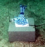
The recruitment of mussels and microphytobenthic (MPB) algae to 28 experimental artificial reefs supporting different patch sizes and density of kelp (Ecklonia radiata) off Maria Island, Tasmania. The recruitment of mussels was assessed using rope fibre habitats, and the recruitment of MPB algae was assessed using microscope slides, positioned across the artificial reef and collected in November 2015. These data were collected to examine how the patch size and density of kelp influences the establishment of MPB algae and mussels.
-
The data is the quantitative abundance of megafaunal invertebrates derived from underwater visual census methods involving transect counts at rocky reef sites around Tasmania. This data forms part of a larger dataset that also surveyed fish abundance and algal cover for the area. The aggregated dataset allows examination of changes in Tasmanian shallow reef floral and faunal communities over a decadal scale - initial surveys were conducted in 1992-1995, and again at the same sites in 2006-2007. There are plans for ongoing surveys. An additional component was added in the latter study - a boat ramp study looking at the proximity of boat ramps and their effects of fishing. We analysed underwater visual census data on fishes and macroinvertebrates (abalone and rock lobsters) at 133 shallow rocky reef sites around Tasmania that ranged from 0.6 - 131 km from the nearest boat ramp. These sites were not all the same as those used for the comparison of 1994 and 2006 reef communities. The subset of 133 sites examined in this component consisted of only those sites that were characterized by the two major algal (kelp) types (laminarian or fucoid dominated). Sites with atypical algal assemblages were omitted from the 196 sites surveyed in 2006. This study aimed to examine reef community data for changes at the community level, changes in species richness and introduced species populations, and changes that may have resulted from ocean warming and fishing. The methods are described in detail in Edgar and Barrett (1997). Primarily the data are derived from transects at 5 m depth and/or 10 m depth at each site surveyed. The underwater visual census (UVC) methodology used to survey rocky reef communities was designed to maximise detection of (i) changes in population numbers and size-structure (ii) cascading ecosystem effects associated with disturbances such as fishing, (iii) long term change and variability in reef assemblages.
-
Community assembly in macrofauna communities developed in artificial kelp holdfasts was monitored at 1-month intervals over a 13 month period using a sampling design that used systematic patterns of temporal overlap and changes in start and collection dates. The hierarchical nature of the experimental design allowed several different approaches to analysis; by date of deployment and by date of collection of the artificial habitats, which enabled comparison of community assembly with and without the seasonal effects of the date of collection, and by community age to test whether there were alternative end-states to assembly depending on season or recruitment history.